
NWS: Potential heavy rainfall in upcoming days
There's a somewhat likely chance that a tropical disturbance will bring rain to the region Friday and Saturday.
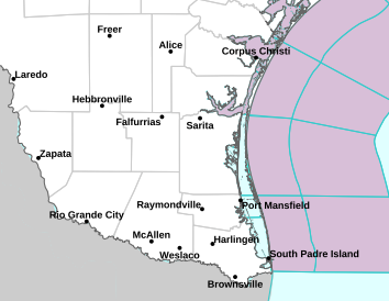
The National Weather Service of Brownsville announced that a disturbance over the Western Gulf has a 40% chance of development within the next two days.
However, NWS said that the system could still bring some much-needed rain.
"Regardless of development, this system could bring locally heavy rainfall to portions of Deep South Texas," NWS said.
As of now, there is a flood watch for Cameron and Hidalgo counties. More so, the flood watch is in effect from Friday morning through the afternoon.
"Excessive runoff may result in flooding of roadways as well as other low-lying and flood-prone locations. Flooding may occur in poor drainage and urban areas," the NWS said.
As a cautionary reminder, the Atlantic Hurricane Season is until Nov. 30. Due to above-average temperatures in the Atlantic Ocean, the National Oceanic and Atmospheric Administration (NOAA) predicted above-normal hurricane activity this year.
Source: NWS